
Whenever you hear the name San Diego, a couple of things should surely cross your mind, like it’s called the finest city of America, great weather, great restaurants, super expensive.
But one of the things that are getting added to the adjectives that describe San Diego are hiking tracks.
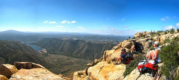
Being situated just at the coast of the Pacific Ocean, this California city is home to over 130 amazing hiking trails. Some of them have so recently been explored that even locals don’t quite know about them.
San Diego has a lot to offer for you hiking fans out there, and this article will tell you about the best hiking trails near San Diego for an outdoor adventure.
Why Hike?
Hiking is considered to be the new yoga of this modern age, and its gaining popularity every day. As of now, there are 45 million people in the USA who go on hiking at least once a year, and it is the fourth most famous and preferred outdoor activity chosen by the Americans.
There has also been a hiking issue of Vogue, so there is no denying that hiking is the new deal now. Why did hiking become so popular? Because it most importantly reduces your stress.
Dealing with life and being in a daily routine ought to take a toll on the human body. So a walk in the wild to reconnect with nature is our only remedy from it.
Research shows, done in the Chiba University in Japan, that a 15-minute walk in nature is bound to reduce our cortisol, which is our stress hormone, by 16% and our blood pressure by 2%. Don’t forget the added excitement and adrenaline rush by just being in the wild.
Why Hike in San Diego?
San Diego is one of the favorite destinations for hikers because of the favorable climate and the diverse landscape.
You can do a number of activities in any topography you want. There are seaside rambles, open hillsides, difficult mountains to climb, and even a challenging trip to the desert; whatever you name, San Diego has that to offer.
Magnificent Shorelines
You already know that San Diego is just along the Pacific Ocean, so it has some magnificent shorelines with picturesque bays, sunny beaches, sundry marshlands, and intertidal lagoons. If you move further to the inland, the landscape becomes drier and hilly.
Leaving the residential area as you explore the wild, you will see how diverse and beautiful nature becomes. Every trail out there is more stunning than the next. Not to mention every trail will surprise you with hidden waterfalls or a stellar view.
Mountains, Forest, Desert and Ocean
If you move to the east of downtown San Diego, you will find mountains with both gentle and fierce slopes. There are a conifer and oak forest upon the hills, and if you look at the forest, you will get to see the vast ocean like its right underneath your feet.
From the hills, the ocean should be on your west, and your east, you should see the desert. Imagine being on top of a hill and having to see both the ocean and the desert in one view. How blissful can life become at that moment?
Wildflowers
As you go out of town towards the deserts, you will see the blooming on wildflowers on the way and experience it yourself as the landscape, and the environment changes around you.
So whether you are a hiking fanatic or you just happen to live in San Diego or somewhere near it, you have to check this county out. San Diego has to offer all that you might be looking for.
Best Hiking Trails near San Diego
You know by now that San Diego is home to numerous hiking trails, but here are our top picks for you so that you make sure you witnessed the beauty with your own eyes. They are as follows.
1. Batiquitos Lagoon Trail

This trail is situated in the Batitquitos Lagoon Ecological Reserve, which is in Carlsbad, about 30 miles north from San Diego, and this trail should be the first choice for your family outings. This is also an excellent trail is you are looking for something quick and easy as the trail is just 3.3 miles.
And this reserve is famous for having a range of habitat, starting with wet mudflats to coastal marshlands. While you are hiking, you will see birds like herons and egrets, which is a sight to cherish.
In the marshlands, you will find rare plants like cattails and pickleweed, if you trail around the waterfront, and sagebrush and yucca if you are hiking a little further in.
The trail is wheelchair or stroller friendly so the kids and the elderly can enjoy the waterfront in peace. You can also add fishing to the hiking activity when you go down this trail.
The Hike of the Batiquitos Lagoon Trail
The trail is right along the north side of the Lagoon itself, and there are five public parking spaces throughout the trail. You start this trail from the end of Gabbiano Lane, given you have free parking space.
If you don’t do that, you have to rethink your starting point. And if you go hiking in the mornings, to your surprise, you will see that locals are using this trail for some early morning exercise. From Gabbiano Lane, the trail leads east.
You keep wandering in the flat, wide and clean trail until you reach the northern shore of the Lagoon. This is why the Batiquitos Lagoon trail is such a popular spot for rookie hikers and young children.
And you can make the trail shorter because for the parking facilities, but if you want to complete the entire trail, then you can go up to Batiquitos Drive and go back the way you came from. If you have your dog with you, make sure it is leashed because that’s the rules of the reserve.
2. Blue Sky Ecological Reserve

This trail is in a reserve called the Blue Sky Ecological Reserve in Poway, which is about 26 miles northeast of San Diego. As the trail is located near the residential neighborhoods, it is said to be one of the most accessible but yet beautiful trails that there is to explore in San Diego.
The reserve itself is 700 acres big, and it’s a canyon so you can easily feel detached from the city life by being nearby. And the trails have open views of the reserves, and the landscape is spectacular starting from oak coppices, then to sagacious littoral scrubs and innate chaparral.
Moreover, the reserve has a bonus service that every weekend they will take our trips with a guide so that you can learn all about the different kinds of animals and plants that are out there. So if you up for some knowledge as well as hiking, this is the place to be.
Furthermore, the hike is about 5 miles long out and back, and it is not very difficult, so it is the perfect place for families to visit and take a break from daily life. You can take your pets with you too as the reserve allow that. However, they must be leashed because it is such a big space with so many different animals.
It would be very difficult to find your pet if it gets misplaced.
The Hike of the Blue Sky Ecological Reserve
The trail starts from the Green Valley Truck, which is basically a wide and big space where families can have picnics as there are benches and restrooms for the people who come there. As you start walking on the trail, you will have to climb through the trees a little while.
About 1.5 miles from the start, you take a hard left, and you will get closer to Lake Ramona. You will see that the trail is getting a bit steeper as you go along. Right by the Lake, the open views start, and sometimes the sun can be harsh, so make sure you have your sun protection, umbrella, and plenty of water to stay hydrated.
As you climb the trail, you will get to see panoramic views of Lake Poway, Lake Ramona, and the very town of Poway. Every often so hikers just stand and take in the magnificent sight that is right in front of them. The air, the sky painted on the waters like it is a canvas, the distant city sounds, this is all a nature lover wants.
And the trail finally comes to an end at the Lake Ramona Dam, where hikers usually take a break and have lunch to prepare their way back. There is another mile of hike left from that spot, but most people just settle beside the dam.
3. Torrey Pines State Reserve Loop

Now we will talk about one of the most famous reserves there is in the US, which is the Torrey Pines Sates Natural Reserve, and it is so famous because it contains one of the rarest pines in America, which is the Torrey Pines. Torrey Pines has no other home except Santa Rosa Island.
The reserve is also famous for its reputation to protect the fragile coastal life that is getting extinct as the days go by. Moreover, the Torrey Pines State Natural Reserve is adjacent to the Los Penaquitos Marsh Natural Preserve, which is home to one of the last salt marshlands in southern California.
And the Torrey Pines State Reserve Loop is in this reserve, which is just 17 miles north of San Diego. The trail is a 2.4-mile round trip loop which beautiful views of the scenic seas. And the serrated cliffs, subterranean ravines, and the quaint stretches of the beach make it one of the most unique and special experiences.
Furthermore, the park comes at your service from 7:15 AM and stays out till sunset making sure you get the best of nature. You generally get a free pass if you have a valid annual California State Park Vehicle Day Use Pass, or otherwise, you have to pay an admission fee per vehicle.
They also have a visitor center which opens at 9 AM, if you need any other information regarding your visit. As mentioned above, the trail is a loop, so you don’t have to worry much about the directions.
However, what you need to worry about are rattlesnakes. The entire park is full of them, so keep both of your eyes and ears open. As this is a beach trail, you have to wear your beach attire and footwear for the hike.
To go for a swim in the Pacific Ocean and do a little picnic with your family right at the beach, be sure to pack some food and changes of clothes with you.
The Hike of the Torrey Pines State Reserve Loop
You will start your hike from the huge parking areas from the north end of the reserve and continue towards the beach. However, if you had to go to the visitor center first, you can start the hike from their as well.
During the first phase of your hike, you will have to climb up a wide path. This part of the hike is not particularly very natural as it is situated just beside the main road, but once you cross that path, the scenery that is about to come is to die for.
When the beach trail starts, the path slowly declines towards the glorious beach and the Pacific Ocean. During the walk, you will see the ravines and the Torrey Pune Clad Hills on your side.
There, feel free to enjoy the beach in any way you want. The beach trail is about a mile, and then before you know it, you are back at the huge parking area, right where you started.
4. Cuyamaca Peak

This hiking trail is located at the Cuyamaca Rancho State Park in Descanso, and it is 50 miles northeast of San Diego. If you are in San Diego, then it will take an hour to drive to the park.
Even though you have to travel quite some time to get there, do not omit it from your list because it is the perfect place for you to hike and camp outside. Aside from the several wide camping grounds, this park offers you several activities like biking and horseback riding.
So if you are taking up the time to go to the Cuyamaca Rancho State Park, make it an overnight or a weekend stay. The best time to go to the hike is the summer as you get a cool retreat from the humidity. With oak and pines forests, meadows, and peninsular range, it is the place to get the best views of San Diego County.
The park also provides facilities like picnic tables, grills, and fire rings in the days of summer when the park stays densely populated with hikers and tourists.
The Hike of the Cuyamaca Peak
The trail is, however, a hike to the Cuyamaca Peak, and it is just 5.5 miles long. Within the first half of the hike, you will have climbed about 1500 feet of the hill. It starts from the Paso Picacho Campground and ends at the very top of the hill. The path is not that clear or clean, but it is obvious.
It is an old fire road that was paved years ago but not maintained like the other reserves, so you will have to be careful with your steps.
And the trail is not open, but it is a climb to an amazing peak, so you need to have your gears and plenty of water with you, especially during the summer. The climb may be tiresome, but once you reach the peak, you will realize that it was worth it. The Cuyamaca peak is 6,512 feet above the ground, which has the most unique view.
On your east, you can see the deserts of San Diego County, and on your west, you have the ocean. And just beneath you, you have Lake Cuyamaca. It will seem like you are standing a thousand feet above the lake itself.
Moreover, the view stretches further north, and on a clear day, you will be able to see Mexican borders from the peak. And in the south, you will get to spot the Catalina Island. Once you have enjoyed your time at the peak, you can just head back down to your camping ground and spend the night in nature.
5. Cowles Mountain Backside Loop

The 3-mile round trip loop is at the Mission Trails Regional Park around 13 northeast of San Diego. This is one of the most easily accessible trails that you can find near San Diego. The reserve has rolling hills and rugged valleys with open peaks and unforgettable views, and that’s what makes it such a good recreation spot.
As it’s very close to San Diego and the neighboring cities, it is one of the favorite spots for locals who love a quick getaway. The park is home to a trail of about 65 miles with different levels of difficulty and not only attracts hikers, but the trails also attract trails runners, mountain bikers, horseback rides, etc.
And the park also has a game for the enthusiastic hikers, which is called the 5 Peak Challenge, to see who can climb the 5 mountains the fastest.
If you are not an extreme outdoor athlete and have a family, then you can swing by the visitor center, which is open from 9 AM to 5 PM daily, and set up a number of activities available in the park. You can also take an educational trip around the park to look at the rich trails, animals, and plants that are found in the mountains.
The Hike of the Cowles Mountain Backside Loop
Cowles Mountain Backside loop is one of the most renowned trails in the park. This 3-mile loop takes you to the peak of the Cowles Mountain itself. The trail starts from the Barker Way Trailhead and then continues along the Cowles Service Road. If you take about the steepness, then you can be assured that the climb is evenly steep.
Sometimes the climb is quick and sometimes rather steep, but that is the beauty of nature, isn’t it? Just before you reach the peak, there are benches on which you can rest and soak up the glorious view in front of you. You can see the downtown of Santee and the hills on your north.
Once you are rested, you can travel to the summit of the Cowles Mountain. From the greatest point of the mountain, you can see the vast Pacific Ocean and the surrounding San Diego County.
Some say they could spend eternity just staring at the vastness of the ocean contrasting with the buzzing city life just below them. Once it is time, you can just follow the path back and come right back where you started.
6. Iron Mountain Peak Trail Number 10

About 30 miles due northeast of San Diego lies the Iron Mountain in the city of Poway, and that is where this trail is located. There are many trails up and around the mountain, but trail number 10 is the prevalent one of them all. The well-kept trails by the City of Poway are a huge attraction to everybody.
And the trails prevail a different look for every season. In spring, you will find wildflowers along the trails, and in summer is scorching hot with dry leaves. However, the rolling hills with forests on its sides and the hard-packed trail are a constant.
The entire area around the mountains has several public toilets so that you can freshen up on any point of the journey. But there is limited parking around the mountain, so you have to make sure you go early and save a spot for yourself.
The Hike of the Iron Mountain Peak Trail Number 10
From the root of the mountain, the hike commences with a gentle climb with a path that has line trees all around it. The scenery, however, quickly changes to the tangled hillside as you start to climb the steeper parts of the trail.
And the path up to the mountain is filled with signposts and direction indications, so there is no risk of wandering off the trail. The trail continues between the Iron Horse trail number 11 and the Iron Peak Mountain Alternate Trail.
As you carry on on the 5.8-mile-long trail of the Iron Mountain Peak Trail Number 10, you will find that the mountain is getting steeper and rockier, so you have to exercise extreme caution.
On the journey to the top, you will pass the junction to Ellie Lane Trail number 12 and head south. At this point, the view from the top becomes worth all the sweat. In front of your eyes, you will see the vast Mother Nature and its wonders. The path is very rocky at this point, and you see some unique boulders on your way to the top.
Just 2 miles away is the summit of the Iron Mountains and the entire city of Poway on your west. On the top, you will get to witness Mount Woodson on your north and San Vicente Reservoir on your southeast.
Enjoy your time at the peak because it was quite a difficult hike. After you are well-rested just head back to the path that took you to the peak in the first place.
7. Palm Canyon Loop

If you are looking for a campsite during your weekends where you can hike to a splendid desert oasis, then Palm Canyon Loop should be on top of your list. This trail in the Anza Borrego Desert State Park in the Borrego Springs, which is about 88 miles northeast of San Diego.
Although it is a two-hour drive from San Diego, the fun begins right from the road trip. The journey from San Diego to Borrego Springs is, in a word, incredible. And once you are in the park and you see the enormous desert in front of you, all your exhaustion from the road trip is going to change into excitement.
This park is home to many hiking trails, a variety of animals and plants which includes the Peninsular Bighorn sheep, which is currently one of the endangered species in the world, and a landscape is so diverse, starting from wildernesses to lush, palm-filled sanctuaries, etc.
In case you are lucky and it is the season, you will witness a manifestation of wildflowers of colors that you don’t even know the names of. And if you stay overnight, you will understand the true beauty of a starry night sky.
The 600,000 acres park is mostly a pristine desert, and you will want to explore it all to fully appreciate its exquisiteness. This park is located in a remote area, so don’t hope for supply stores nearby.
Make sure you have everything you need starting from loads of food and water, sun protection, bug spray, and whatever you may need. The park is always open from dusk to dawn, and they charge a “day use” fee to whoever stays there.
The Hike of the Palm Canyon Loop
The infamous 3-mile hike of the Palm Canyon is one of the park’s main attractions. Hikers who have the basic knowledge and fitness for a moderately difficult hike will love this place as the conditions are kept quite harsh.
And the path is quite rocky. So you have to concentrate on finding your way, and that is the thrill newbie hikers love. The trail starts from the parking area, which is on the west side of the park. And the first phase of the hike is quite simple as there are well-marked indications of the path.
Also, the path is smooth and sandy, and around you is the open space with low undergrowth and wildflowers. After traveling for about 0.5 miles, the path heads north, and you enter the canyon. You will cross the Borrego Palm Canyon Stream on your way through the canyon.
As you look ahead, you can spot the cluster of California fan palms at the oasis. And as the trail continues, the path becomes rocky and difficult to keep pace you were keeping previously.
Moreover, the lack of directions makes it difficult to keep track of the path as well, so look out for arrows in the massive open desert. Keep on going down the stream to reach the haven. This is one of the few places that will offer you some shade, so enjoy it while you can.
Unlike most hike trails, you don’t have to go back the way you came from. To return to the starting point, you can take an alternate route, which is the Palm Canyon Alternate Trail, and enjoy the canyon a little more.
8. Cedar Creek Falls

Want to stand on the edge of spring and look up to see an amazing waterfall pouring from a rocky hillside? Then what are you waiting for? Pack your bags and head to the Cleveland National Forest, which is 68 miles northeast of San Diego, to see the Cedar Creek Falls right now.
Cleveland National Forest is extremely popular itself for its rich vegetation and wilderness, and having the Cedar Creek Falls is just the cherry on top. You can travel to the fall using two trails, one is the San Diego River Gorge Trailhead, aka the Thronbush Trailhead, and the other is the Saddleback Trailhead.
Whichever trail you choose, it is approximately 4.6 miles long and in a lollipop loop shape, and you have to buy a day-use permit, which can also be booked earlier from online. Both the trails are equally perplexing, so it’s quite hard to choose between them.
People usually just go with guts or whichever is accessible to them in terms of location or parking. The journey can really exhaust you, so make sure you have plenty of water with you because, especially during summer, the heat is unbearable.
The Hike of the Cedar Creek Falls
The hike to this wonderful fall is not easy at all, and that is mainly because of the elevation change and the exposed areas, which makes the surroundings so hot. If you take the Saddleback Trailhead, then you have to go towards the Eagle Peak Road.
This path is quite narrow and not clean at all, so be prepared to cut some overgrown plants on your way. Eventually, the trail will descend downhill into open views of the river valley. If you try, then you will see Mildred Falls at a distance way up north, although water doesn’t always flow through the falls now.
And then the trail goes downhill. Furthermore, going through a ridge which brings the San Diego River closer until you come to an intersection with the San Diego River Gorge Trail. From there, you turn left and continue on the path beside the Cedar Creek until you finally arrive at the Bravura fall.
Moreover, the fall is about 80 feet tall and has a watering pool in front of it, so feel free to dive into the cool water to bring down your body temperature by a couple of degrees.
Do not get carried away in the refreshment, though. You have to be careful about using the watering hole because there are slippery rocks all around it. Nobody would want to ruin their amazing trip to this wonderful fall by getting hurt.
Also, it is strictly prohibited to climb the hills around the falls as it is not safe. After you have had your fun, just go back the way you came.
9. Three Sisters Fall

This is also located at the Cleveland National Forest, just like the Cedar Creek. This fall is recently gaining its popularity for splendor. To get to the Three Sister Falls, you will have to hike for about 3.7 miles out and back, but it is so worth the effort. The area is reported to be crowded on weekends and summers.
Previously the hike to the falls was so difficult that some found it to be impossible and returned home. Recently the path has been clean and restricted, so the Three Sister Falls is quite accessible to people now. However, the difficulty level of the path is said to be extreme.
So you need a healthy body and some basic experience to complete the hike.
The fall is in such a remote place that you really cannot rely on anything else other than what you carry on your shoulders, so hikers are asked to be fully prepared for any situation that may arise. Summers can be torturous, so having enough water to keep you hydrated is a must.
The Hike of the Three Sisters Fall
The expedition to the Three Sisters Falls starts off at the Boulder Creek Road, and from there, you have to head west on a wide, guarded fire road. And the first mile of the 3.7-mile hike is quite horizontal, with a little decline slope. But when you take the south turn, it starts to descend drastically.
Then, the fire road disappears and what appears to be a single-track trail that will crawl down the canyon. As the path continues, it becomes harsh and steeper in the downhill direction, so make sure you follow the directions carefully.
As you come closer to the Boulder Creek, the trail just drops downhill several times, so you have to use ropes to levitate down to places. This requires time, patience, caution, and experience.
Once you have reached the Creek, in front, you will see the Three Sisters Fall. If it rained in San Diego any time soon, then the falls will be massive. Even if the water is low, however, it is a sight to see.
There is a watering hole right in the middle, so you can soak your feet in the cool water and let off some steam. Be careful not to waste all of your remaining energy at the falls because the return trip is uphill and quite severe. You will have to travel uphill, and it will be more difficult than the trip that got you to the falls.
10. Potato Chip Rock

This hiking trail is the most difficult of all the trails mentioned above because first off, it is 7.1 miles out and back in length. Just 27 miles northeast of San Diego lies the Potato Chip Rock trail in the Lake Poway Park in the city of Poway. If you want a rocky adventure that tests your strengths and limits, then this is the trail for you.
Lake Poway Park will give you all the facilities that a city park has to offer, like public toilets, restrooms, picnic areas, and many trailheads, so this is the perfect place to spend a day if you’re looking for an adrenaline rush.
The park opens at 6 AM and stays open till sundown. With the hike to the hilly areas in the park and surrounding Lake Poway, visitors can also go fishing and boating on the lake and make a day out of it. The park, however, does not have any residential facilities, so you have to purchase a day-use pass at the entry point of the park.
Just like in any hiking expeditions, make sure you have everything you need because the hike to Mount Woodson through the Potato Chip Rock trail is a long and difficult one. Water and sun protection is an absolute must because the trail is not shaded at all.
The Hike of the Potato Chip Rock
The hike begins from the Lake Poway Staging area, which is on the west side of the lake. From there, you follow the path and head southeast on the Lake Poway Trail, which takes you to the southern shore of the lake itself. After about a mile of walking on that trail, you turn right and enter the Mount Woodson Trail.
And the trails are smooth and uniformly steep so you can climb the mountain at a steady pace and get beautiful views of the other mountains around the trail. As you catch a breather from time to time, look back and observe the glorious Lake Poway from above.
Moreover, the next phase of the hike is where it gets so difficult that very few people make it to the top. For the next 3 miles, all you will find are mean steep uphill cuts to the top and very little shade to protect you from the sweltering sun.
As you make the climb, you will see some of the most unusual boulders that you have ever seen, and it gets more fascinating as you get near the peak of Mount Woodson.
From the peak, you can enjoy the expanse of Lake Poway the way it should be appreciated. Rest up and then head right back as a long and more challenging journey awaits you.
Conclusion
Here are the top ten hiking trails that you can find near San Diego. If the description didn’t get you interested in at least visiting the places once, then I think you really need to reconnect with Mother Nature, my friend.
Whenever we talk about hiking, we must remember to be safe, so make sure you have your hiking gears and first aid with you at all times. And of course, don’t forget to stay hydrated. So what are you waiting for? Let’s channel our spirits and start hiking!
SeaRanchLodge.com is a participant in the Amazon Associate program and will earn from qualifying purchases.